Karst
China is one of the countries in the world with largest carbonate rock occurred, and it is in south China that the most typical and diverse karst landforms developed. Centered by Guizhou Province and covering some 600,000 square kilometers the South China Karst terrain is believed the largest single karst area in the world, including eastern Yunnan, most of Guizhou, with a major extension into parts of Chongqing, Sichuan, Hunan, Hubei and Guangdong. With high altitude plateau (average 2000-2200 meters elevation) in the northwest and low-lying plain (average 100-120 meters elevation) in the southeast, the overall topography features a giant slope declining from northwest to southeast.
Contents
South China Karst
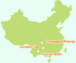
South China Karst is the title of the serial application for the World Natural Heritage by Chinese Government. The nominated property (Phase 1) comprises three areas of Chongqing Wulong Karst (gorge), Guizhou Libo Karst (cone) and Yunnan Shilin Karst (pinnacle). The total area of the three sites covers core area of 476 sq.km. and the buffer zones of 984 sq.km.
Form different perspectives, the karst areas comprehensively reflect the unique natural features of the South China Karst terrain, highlighting its special and representative karst landforms, karst ecosystem and biodiversity, and exceptional natural beauty.
Geologically, the South China Karst region is located in the southwest margin of Yangtze landmass, in most Paleozoic and early Mesozoic period (Cambrian to Triassic), this region was oceanic environment with lower latitude than present. Thousands meters thick carbonate layers, particularly late Paleozoic period (Devonian, Carboniferous and Permian), deposited. Due to earth movement, this region was uplifted as land since late Triassic and started its karst landform development. Drawn by the Himalayan mountain building since late Tertiary, this region experienced a rapid tilting uplift which resulted in its today's sloping topography.
Long term complex geological evolution gave rise to exceptional diverse karst landforms in this region, including the most typical karst landforms in the world of tower kart (Fenglin), pinnacle karst (Stone Forest), and cone karst (Fengcong), as well as some unusual karst phenomena such as Tiankeng (giant karst pit) and Difeng (deep karst fissure). Besides, there are numerous spectacular underground cave systems and rich cave sediments. All these make this region the world's "museum of continental tropic-subtopic karst" because of its unrivaled richness and uniqueness.
Within the South China Karst area, the thick carbonate layers that deposited from Cambrian to Triassjc contain some globally significant fossils such as the Fauna of keichousaurus Hui , etc. which are the important life record of the earth.
The nominated area has richest biodiversity, containing abundant rare, endangered and indigenous pant and animal species. In Chogngqing and Guizhou karst areas there are more than 6000 higher plant species, including D.involucrate, C. argyrophyll, Cycas guizhouensis, Taxus chinensis, etc. threatened and endemic species. This karst terrain is not only the home to plenty of animals ranging from beasts, birds, amphibians, fish as well as cave animals but also the home to many threatened and indigenous, species such as Presbytis francoisi, Neofelis nebulosa, Aqila chrysaetos, Moschus berezovskit, etc. i.e, the nominated area is the sanctuary to many threatened plant and animal species.
Rich and unique karst landforms contained in the nominated area display exceptional natural beauty, many areas have long been traditional Chinese scenic resorts for hundreds years, of which, the tiankengs in Chongqing, Stone Forest in Yunnan and the Guizhou waterfalls are world-renown natural wanders.
On June 23, 2014, the World Heritage Committee added an extension of South China Karst to the World Heritage List of the United Nations Educational, Scientific and Cultural Organization (UNESCO).
The extension, with a total area of 1,186 square kilometers, includes the Jinfoshan cluster in Chongqing Municipality, the Shibing cluster in Guizhou Province, and the Guilin and Zhujiang clusters in Guangxi Zhuang Autonomous Region -- all in southwest China.
Libo Karst
Libo Cone Karst Nominated Site of South China Karst application for World Natural Heritage lies in Libo County, South Guizhou Buyi and Miao Autonomous Prefecture, Guizhou Province, and has a mean altitude of 747m ranging from 385 to 1109m.
It is a typical site of cone karst on the transitional zone between Guizhou plateau and Guangxi lowland, outstanding for their full spectra of gradual change from plateau karst to the lowland karst. The cone karst landscape supports immense biodiversity and this special karst forest ecosystem is the habitat of many endemic species and endangered fauna.
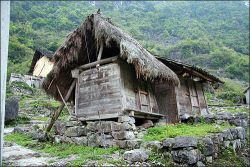
The nominated sites, where 90 percent of their populations are minorities, are rich in culture. The exotic local minority culture is the colorful and unique ethnic groups of Shui, Yao, Buyi, etc. The delimitation of boundary for the Libo Karst Nominated Sites mainly accords to the integrality of cone karst geomorphology development and distribution, karst forest ecosystem and habitat of rare and endangered species. The boundary keeps coherence with the boundary of Maolan National Nature Reserve and Daqikong and Xiaoqikong Spots in Libo Zhangjiang National Scenic Area.
The Libo Karst comprises core area of 29,518 hectares and buffer zones of 43.498 hectares. The core area of the Maolan National Nature Reserve nominated site covers 21,684 ha. taking up 73.46 percent of the cone area of the Libo nominated sites.
The criteria satisfied for the World Natural Heritage is as below:
Be outstanding examples representing major stages of the earth evolutionary history, including the records of life, significant on-going geological processes in the development of landforms, or significant geomorphic or physiographic features;
Be outstanding examples representing significant on-going ecological and biological processes in the evolution and development of terrestrial, fresh water, coastal and marine ecosystems and communities of plants and animals;
Contain the most important and significant natural habitats for in-situ conservation of biological diversity including those containing threatened species of outstanding universal value from the point of view of science or conservation.
Chongqing Wulong Karst
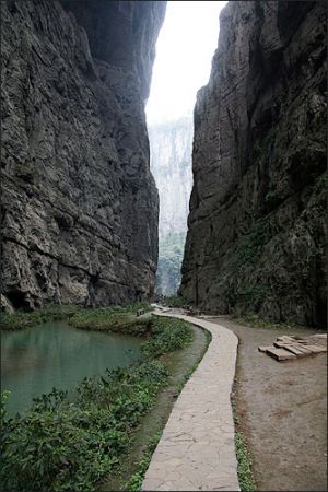
The Wulong Karst is located at Wujiang River downriver of Southeastern Chongqing, and it includes three karst systems of Sanqiao Natural Bridges, Furong Jiang karst gorge and caves round, and Houping erosion tiankengs, which are distributed in mid-north, southeast and northeast of Wulong County respectively. It consists of gorges, natural bridges, tiankengs, caves, shafts subterranean streams and resurgences, developing in the carbonate rocks of Cambrian-Ordovician systems and Permian-Triassic systems.
The macro-landform in this terrain is featured by two-leveling mountain planes with elevations of 1800-2000m and 1200-1500m and deep-cut gorges. The three karst systems lie in the bank, interfluve and headstream of Wujiang River branches respectively; and they formed an interrelated integrity for its developing successively and distributing in sequence.
Wujiang River is one of big tributaries of Yangtze River, with a section of 79km long in Wulong and an incised depth of one kilometer. It influenced intensely the development of its branches such as Furong Jiang, Yangshui He, Muzong He geomorphic systems, for its continuous river incising and vadose zone increasing since the tertiary, and it is the main dynamic genesis of Wulong Karst.
The Wulong Karst records vividly the unique characters of gorge, cave and tiankeng karst development and evolvement under the intermittence tectonic uplifting conditions in Three Gorges area since Cenozoic era for 65Ma, representing major stages of earth evolutionary history.
Big Events of Wulong Karst:
- May 1993-Furong Dong was discovered;
- May 1994-Furong Dong show cave was opened;
- Since 1994-Approximately 100km long cave passages have been surveyed by cavers from over ten countries;
- March 2001-Qingkou tiankeng as erosion tiankeng type was discovered by Prof. Zhu Xuewen;
- October 2003-Wulong Karst was ratified National Geopark of China by Ministry of Land and Recourses;
- January 2006-Wulong Karst, as a part of South China Karst, applied for world natural heritage.
Guizhou Libo Karst
Libo Cone Karst Nominated Site of South China Karst application for World Natural Heritage lies in Libo County, South Guizhou Buyi and Miao Autonomous Prefecture, Guizhou Province, and has a mean altitude of 747m ranging from 385 to 1109m.
It is a typical site of cone karst on the transitional zone between Guizhou plateau and Guangxi lowland, outstanding for their full spectra of gradual change from plateau karst to the lowland karst. The cone karst landscape supports immense biodiversity and this special karst forest ecosystem is the habitat of many endemic species and endangered fauna.
The nominated sites, where 90 percent of their populations are minorities, are rich in culture. The exotic local minority culture is the colorful and unique ethnic groups of Shui, Yao, Buyi, etc. The delimitation of boundary for the Libo Karst Nominated Sites mainly accords to the integrality of cone karst geomorphology development and distribution, karst forest ecosystem and habitat of rare and endangered species. The boundary keeps coherence with the boundary of Maolan National Nature Reserve and Daqikong and Xiaoqikong Spots in Libo Zhangjiang National Scenic Area.
The Libo Karst comprises core area of 29,518 hectares and buffer zones of 43.498 hectares. The core area of the Maolan National Nature Reserve nominated site covers 21,684 ha. taking up 73.46 percent of the cone area of the Libo nominated sites.
The criteria satisfied for the World Natural Heritage is as below:
- Be outstanding examples representing major stages of the earth evolutionary history, including the records of life, significant on-going geological processes in the development of landforms, or significant geomorphic or physiographic features;
- Be outstanding examples representing significant on-going ecological and biological processes in the evolution and development of terrestrial, fresh water, coastal and marine ecosystems and communities of plants and animals;
- Contain the most important and significant natural habitats for in-situ conservation of biological diversity including those containing threatened species of outstanding universal value from the point of view of science or conservation.
Yunnan Shilin Karst
The Stone Forest National Park is located in Shilin Yi Autonomous County of Yunnan Province, 80 kilometers southeast of Kunming City. It covers 350 square kilometers and consists of Major Stone Forest, Naigu Stone Forest, Changhu Lake, Grand Waterfall, etc.
Over the past 300 million years the Stone Forest area has experienced a vicissitude from sea to land, from lowland to plateau as a result of earth movement. The initial carbonate rock which formed in ocean was wizardly shaped into "stone forest" landform. During its evolution the Stone Forest were once covered respectively by fiery volcanic lava and lake water, in this sense the formation of the Stone Forest is truly a geologic legend in the world.
The Stone Forest displays the richest morphological features. Due to its unique geological evolution, numerous stone forest clusters that formed in different geological periods coexist in varied topography, each with its particular features. There are pinnacle-shaped, column-shaped, mushroom-shaped, and pagoda-shaped groups. Since almost all the typical pinnacle karst types can be identified in the Stone Forest, the park is acclaimed internationally the "Museum of Stone Forest karst".
Walking through the Stone Forest, visitors marvel at the natural stone masterpieces and are bewitched by the intricate formations. The magnificent, strange and steep landscape creates countless labyrinthine vistas, including:
Major Stone Forest, Small Stone Forest and Naigu Stone Forest, all of which feature stones in various formations. Animals, plants, and even human figures can be found here. Some are elegant, some are rugged, and each is lifelike with its own distinguishing characteristics.
Subterranean Stone Forest in Zhiyun Cave, an underground stone forest distributed among several caves and occupying a total area of about three square kilometers.
Strange Wind Cave, composed of Penfeng Cave, Hongxi Spring and an underground river. From August to November, gales lasting two to three minutes sweep out of the cave every 30 minutes.
Long Lake is a karsts lake that is three kilometers (two miles) long but only 300 meters (zero point two miles) wide. The lake features underwater stalagmites and stalactites and a small island in the center of the water.
The source of the Dadie Waterfall, Ba River, is a branch of Nanpan River. In the rainy season, up to 150 cubic meters (196 cubic yards) of water per square inch plummet down the 88 meter (288 feet) drop.
Every year, around the 24th and 25th day of the sixth lunar month, the Sani people gather in the Stone Forest to celebrate their "Torch Festival". Visitors are welcome to enjoy the folk dances and the wrestling competitions of the Sani youngsters.


