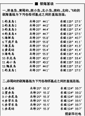
Territorial sea baseline
A territorial sea baseline (领海基线) is the starting line from which the width of a coastal country's territorial sea, and certain other maritime zones under its jurisdiction, are measured. The water areas located within the line and linked to the land are considered internal waters. The water areas outside of the line then, are first territorial waters, and after that jurisdictional waters, including the Exclusive Economic Zone and the Continental Shelf.
The Japanese government's decision to "purchase" the Diaoyu Islands sparked a determined response from China. On Sept. 10, 2012, the Chinese government announced the baselines of the territorial waters of the Diaoyu Islands and their affiliated islets, as well as the names and coordinates of 17 base points, in accordance with the Law of the People's Republic of China on Its Territorial Seas and Adjacent Zones.
The Chinese government has reiterated that the Diaoyu Islands are an inalienable part of China's territory and China will make no concessions on issues concerning its sovereignty and territorial integrity. Meanwhile, the Chinese government announced that it will conduct a normalized surveillance and monitoring of the Diaoyu Islands and its affiliated islets.
