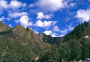
Mount Tianshan
From Wiki China org cn
Revision as of 04:54, 21 April 2010 by imported>Ciic (Created page with 'Lying in northwestern Xinjiang, '''Mount Tianshan''' stretches 1,700 km from east to west and about 250-300 km from north to south, with the Jungar Basin to the north and Tar...')
Lying in northwestern Xinjiang, Mount Tianshan stretches 1,700 km from east to west and about 250-300 km from north to south, with the Jungar Basin to the north and Tarim Basin to the south. Its Tomur Peak towers 7435 m above sea level, and Bogda Peak, 5445 m.
Mount Tianshan is China’s biggest glacier zone. Its numerous glaciers have formed ice wells, ice caves, ice underground rivers, seracs and other spectacular sights, known as Xinjiang’s biggest “solid reservoir.” Tianchi (Heavenly Pond) is one of the most mysterious attractions of Mount Tianshan.
