Difference between revisions of "Junggar Basin"
From Wiki China org cn
imported>Graceshanshan |
imported>Graceshanshan |
||
| Line 2: | Line 2: | ||
---- | ---- | ||
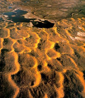
| − | Situated between the [[Tianshan]] and [[Altay]] mountains in north [[Xinjiang Uygur Autonomous Region]], it is the second largest basin in [[China]], covering 380,000 square km. With its base averaging 200-1,000 meters above sea level, the basin has a terrain descending from the east to the west, with its central part covered with grasslands and deserts. It abounds in coal and oil reserves. | + | [[File:Junggar Basin.jpg|thumb|left|Junggar Basin]]Situated between the [[Tianshan]] and [[Altay]] mountains in north [[Xinjiang Uygur Autonomous Region]], it is the second largest basin in [[China]], covering 380,000 square km. With its base averaging 200-1,000 meters above sea level, the basin has a terrain descending from the east to the west, with its central part covered with grasslands and deserts. It abounds in coal and oil reserves. |
[[Category:Basins of China]] | [[Category:Basins of China]] | ||
Revision as of 00:41, 23 June 2009
Junggar Basin
Situated between the Tianshan and Altay mountains in north Xinjiang Uygur Autonomous Region, it is the second largest basin in China, covering 380,000 square km. With its base averaging 200-1,000 meters above sea level, the basin has a terrain descending from the east to the west, with its central part covered with grasslands and deserts. It abounds in coal and oil reserves.
