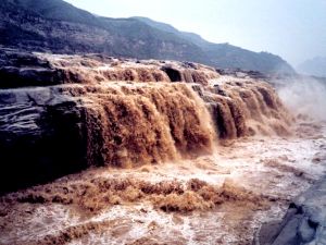
Yellow River
The second largest in China, it originates from the northern foot of Bayan Har Mountain in Qinghai Province. It flows 5,464 km easterly across nine provinces and autonomous regions before emptying into the Bohai Sea. With a drainage area of more than 750,000 square km, its annual runoff is 66.1 billion cubic meters. It has more than 40 tributaries, of which Fenhe and Weihe rivers are the main ones.
The middle section of the river traverses the Loess Plateau with loose soils, making it a river with highest silt content in the world. Around a quarter of the total silt it carries is deposited at downstream riverbeds, making them rise 10 cm a year on average. Thus, the riverbed of many downstream sections of the river is 3 to 5 meters higher than the surrounding land.
The upstream of the Yellow River runs through the junction of the country's first- and second-terrace regions, a section reserving most waterpower resources of the river. Many water conservancy projects have been built in this area, including those at Longyangxia, Liujiaxia and Qingtongxia. The middle reaches of the river also abound in waterpower resources. The Xiaolangdi Water Project, completed in 2001, is situated in Henan Province.
