Difference between revisions of "Qaidam Basin"
From Wiki China org cn
imported>Graceshanshan |
imported>Ciic m |
||
| Line 1: | Line 1: | ||
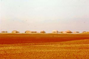
[[File:cdm.jpg|thumb|left|Qaidam Bsin]]Situated in northwest [[Qinghai Province]] in the northeastern part of the [[Qinghai-Tibet Plateau]], the basin is surrounded by the Kunlunshan and Qilianshan mountains. It covers 220,000 square km, with its base averaging 2,700-3,000 meters above sea level. [[Gobi]] deserts, hills, plains and lakes are distributed from the fringe to the center of the basin, which has a terrain descending from the northwest to the southeast, where there are a large number of salty lakes and swamps. | [[File:cdm.jpg|thumb|left|Qaidam Bsin]]Situated in northwest [[Qinghai Province]] in the northeastern part of the [[Qinghai-Tibet Plateau]], the basin is surrounded by the Kunlunshan and Qilianshan mountains. It covers 220,000 square km, with its base averaging 2,700-3,000 meters above sea level. [[Gobi]] deserts, hills, plains and lakes are distributed from the fringe to the center of the basin, which has a terrain descending from the northwest to the southeast, where there are a large number of salty lakes and swamps. | ||
| − | [[Category:Basins | + | [[Category:Basins]] |
Revision as of 01:59, 31 July 2009
Situated in northwest Qinghai Province in the northeastern part of the Qinghai-Tibet Plateau, the basin is surrounded by the Kunlunshan and Qilianshan mountains. It covers 220,000 square km, with its base averaging 2,700-3,000 meters above sea level. Gobi deserts, hills, plains and lakes are distributed from the fringe to the center of the basin, which has a terrain descending from the northwest to the southeast, where there are a large number of salty lakes and swamps.
