Difference between revisions of "Yangtze River"
(PEPiIsKNoN) |
imported>Ciic |
||
| (36 intermediate revisions by 12 users not shown) | |||
| Line 1: | Line 1: | ||
| − | + | {| align="right" border="1" | |
| + | |+ | ||
| + | |- | ||
| + | | | ||
| + | [[Image:Yr.jpg|thumb|right|200px]] | ||
| + | |||
| + | |||
| + | |||
| + | <font color="#0000ff">'''Yangtze River'''</font> | ||
| + | |||
| + | <font color="#0000ff"></font>Yangtze River Length:6,300 km | ||
| + | |||
| + | Annual runoff: 951.3 billion cubic meters | ||
| + | |||
| + | |} | ||
| + | |||
| + | The largest in China and the third longest in the world, the''' Yangtze''' ('''长江''') rises from Geladaindong, the highest peak of the [[Tanggulashan Mountains]]. It flows 6,300 km eastward traversing 11 provinces, autonomous regions and municipalities before emptying into the [[East China Sea]]. | ||
| + | |||
| + | It has numerous tributaries, including the [[Yalongjiang]], [[Minjiang]], [[Jialingjiang]], [[Hanjiang]], [[Wujiang]], [[Xiangjiang]] and [[Ganjiang]] rivers, with a combined drainage area of over 1.8 million square km, accounting for 18.8 percent of China's total area. Its annual runoff stands at 951.3 billion cubic meters, accounting for 52 percent of the national total. It is a major artery of inland water transportation in China. | ||
| + | |||
| + | Flowing easterly from Fengjie County, [[Chongqing Municipality]], to [[Yichang City]], [[Hubei Province]], the Yangtze cuts across [[Wushan Mountain]], forming three gorges with a total length of 193 km. The famous [[Three Gorges Water Project]] began construction at the eastern section of the area in 1994. After completion in 2009, the project is expected to be able to control catastrophic flooding in nearby drainage areas that occurs once in a century. It is also expected to annually generate 84.7 billion kwh of electricity, improve navigation conditions, and ensure water supply in urban areas and irrigation of farmland in the middle and lower reaches of the Yangtze River. | ||
| + | |||
| + | [[Category:Rivers_of_China]] | ||
Latest revision as of 06:59, 8 January 2016
|
Yangtze River Yangtze River Length:6,300 km Annual runoff: 951.3 billion cubic meters |
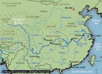
The largest in China and the third longest in the world, the Yangtze (长江) rises from Geladaindong, the highest peak of the Tanggulashan Mountains. It flows 6,300 km eastward traversing 11 provinces, autonomous regions and municipalities before emptying into the East China Sea.
It has numerous tributaries, including the Yalongjiang, Minjiang, Jialingjiang, Hanjiang, Wujiang, Xiangjiang and Ganjiang rivers, with a combined drainage area of over 1.8 million square km, accounting for 18.8 percent of China's total area. Its annual runoff stands at 951.3 billion cubic meters, accounting for 52 percent of the national total. It is a major artery of inland water transportation in China.
Flowing easterly from Fengjie County, Chongqing Municipality, to Yichang City, Hubei Province, the Yangtze cuts across Wushan Mountain, forming three gorges with a total length of 193 km. The famous Three Gorges Water Project began construction at the eastern section of the area in 1994. After completion in 2009, the project is expected to be able to control catastrophic flooding in nearby drainage areas that occurs once in a century. It is also expected to annually generate 84.7 billion kwh of electricity, improve navigation conditions, and ensure water supply in urban areas and irrigation of farmland in the middle and lower reaches of the Yangtze River.
