Difference between revisions of "Air Defense Identification Zone"
imported>Ciic |
imported>Ciic |
||
| (One intermediate revision by the same user not shown) | |||
| Line 5: | Line 5: | ||
The zone is an early-warning air defense concept and can extend in some cases up to 300 miles beyond the territorial sea. When entering the zone, all aircraft are required to identify themselves, report flight plans, and inform ground control of their exact position. | The zone is an early-warning air defense concept and can extend in some cases up to 300 miles beyond the territorial sea. When entering the zone, all aircraft are required to identify themselves, report flight plans, and inform ground control of their exact position. | ||
| − | More than 20 countries have demarcated air defense identification zones on high seas or international waters since the 1950s, including the United States, Canada, Australia, South Korea, Japan, Myanmar, Cuba, Finland, Greece, India, Iceland, Italy, Libya, Panama, Philippines, Germany, Thailand, Turkey and | + | More than 20 countries have demarcated air defense identification zones on high seas or international waters since the 1950s, including the United States, Canada, Australia, South Korea, Japan, Myanmar, Cuba, Finland, Greece, India, Iceland, Italy, Libya, Panama, Philippines, Germany, Thailand, Turkey, Vietnam and China. |
| + | <br> | ||
| − | ==Origin== | + | == Origin == |
In 1940, the United States proposed the idea of "establishing a network for airspace vigilance along its coasts." After World War II, military powers led by the U.S. and the Soviet Union put a large number of high-speed jet fighters into service, which put a number of countries' traditional air defense at risk. | In 1940, the United States proposed the idea of "establishing a network for airspace vigilance along its coasts." After World War II, military powers led by the U.S. and the Soviet Union put a large number of high-speed jet fighters into service, which put a number of countries' traditional air defense at risk. | ||
| Line 16: | Line 17: | ||
Later, after ICBMs were developed and the Soviet Union had been dissolved, the North American ADIZ became less important. However, the 9/11 attacks have once again made ADIZs an important issue over the last decade. | Later, after ICBMs were developed and the Soviet Union had been dissolved, the North American ADIZ became less important. However, the 9/11 attacks have once again made ADIZs an important issue over the last decade. | ||
| − | == ADIZs of major countries == | + | == ADIZs of major countries == |
| − | === The United States === | + | === The United States === |
*Number of ADIZs:4 (The Contiguous US ADIZ, Alaska ADIZ, Guam ADIZ and Hawaii ADIZ) | *Number of ADIZs:4 (The Contiguous US ADIZ, Alaska ADIZ, Guam ADIZ and Hawaii ADIZ) | ||
| Line 26: | Line 27: | ||
*Range: The U.S. set up ADIZs according to geographical location. Besides the American mainland, Alaska, Guam and Hawaii all have ADIZs, which extend towards Russia, China and North Korea respectively. | *Range: The U.S. set up ADIZs according to geographical location. Besides the American mainland, Alaska, Guam and Hawaii all have ADIZs, which extend towards Russia, China and North Korea respectively. | ||
| − | === Japan === | + | === Japan === |
*Number of ADIZs:4 (northern, centre, western and southwestern) | *Number of ADIZs:4 (northern, centre, western and southwestern) | ||
| Line 40: | Line 41: | ||
<br> | <br> | ||
| − | === South Korea === | + | === South Korea === |
*Number of ADIZs:1 | *Number of ADIZs:1 | ||
| Line 50: | Line 51: | ||
=== China === | === China === | ||
| − | [[Image:Adiz3.jpeg|thumb|300px]] On Nov. 23, 2013, China established its first air defense identification zone over the East China Sea in accordance with Chinese law and international practices to safeguard its sovereignty. | + | [[Image:Adiz3.jpeg|thumb|300px]] |
| + | On Nov. 23, 2013, China established its first air defense identification zone over the East China Sea in accordance with Chinese law and international practices to safeguard its sovereignty. | ||
The East China Sea Air Defense Identification Zone includes the airspace within the area enclosed by China's outer limit of the territorial sea and the following six points: 33º11'N (North Latitude) and 121º47'E (East Longitude), 33º11'N and 125º00'E, 31º00'N and 128º20'E, 25º38'N and 125º00'E, 24º45'N and 123º00'E, 26º44'N and 120º58'E. | The East China Sea Air Defense Identification Zone includes the airspace within the area enclosed by China's outer limit of the territorial sea and the following six points: 33º11'N (North Latitude) and 121º47'E (East Longitude), 33º11'N and 125º00'E, 31º00'N and 128º20'E, 25º38'N and 125º00'E, 24º45'N and 123º00'E, 26º44'N and 120º58'E. | ||
Latest revision as of 07:10, 11 December 2013
An air defense identification zone (ADIZ) (防空识别区), also called an air defense identification circle, is a special airspace over the water that coastal countries establish, to protect their territorial sea and airspace.
The zone is an early-warning air defense concept and can extend in some cases up to 300 miles beyond the territorial sea. When entering the zone, all aircraft are required to identify themselves, report flight plans, and inform ground control of their exact position.
More than 20 countries have demarcated air defense identification zones on high seas or international waters since the 1950s, including the United States, Canada, Australia, South Korea, Japan, Myanmar, Cuba, Finland, Greece, India, Iceland, Italy, Libya, Panama, Philippines, Germany, Thailand, Turkey, Vietnam and China.
Contents
Origin
In 1940, the United States proposed the idea of "establishing a network for airspace vigilance along its coasts." After World War II, military powers led by the U.S. and the Soviet Union put a large number of high-speed jet fighters into service, which put a number of countries' traditional air defense at risk.
To increase the response distance and time for an early warning, the U.S. and Canada established the world's first-ever ADIZ – the North America Air Defense Identification Zone in the 1950s.
Later, after ICBMs were developed and the Soviet Union had been dissolved, the North American ADIZ became less important. However, the 9/11 attacks have once again made ADIZs an important issue over the last decade.
ADIZs of major countries
The United States
- Number of ADIZs:4 (The Contiguous US ADIZ, Alaska ADIZ, Guam ADIZ and Hawaii ADIZ)
- Farthest distance from its shoreline: 250 nautical miles
- Range: The U.S. set up ADIZs according to geographical location. Besides the American mainland, Alaska, Guam and Hawaii all have ADIZs, which extend towards Russia, China and North Korea respectively.
Japan
- Number of ADIZs:4 (northern, centre, western and southwestern)
- Farthest distance from its shoreline: 800 kilometers
- Range: Covers its territorial airspace, seas and Exclusive Economic Zone, as well as China's Diaoyu Islands territorial airspace and seas in the west.
After Japan's surrender in 1945, the US demarcated an identification zone off Japan's coasts, but it was under the control of the US military in Japan. It was only until 1969 that the US transferred the management of the zone to Japan.
After that, Japan expanded the zone westward twice, once in 1972, the other in 2010. Japan follows a warning sequence for unidentified aircraft: radar detection, emergency calls, fighter emergency launch, requiring forced landing, and bomb warning. Once its own aircraft, land, or vessels are attacked, a defense war will be launched. However, territorial disputes still exist, as the zone is not recognised by Japan's neighbors, Russia and China.
South Korea
- Number of ADIZs:1
- Farthest distance from its territorial airspace: 390 kilometers
- Range: South Korea's ADIZ boundary is far from its territorial airspace, to guarantee that it can deal with unknown situations effectively.
China
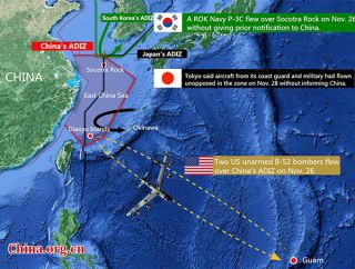
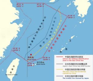
On Nov. 23, 2013, China established its first air defense identification zone over the East China Sea in accordance with Chinese law and international practices to safeguard its sovereignty.
The East China Sea Air Defense Identification Zone includes the airspace within the area enclosed by China's outer limit of the territorial sea and the following six points: 33º11'N (North Latitude) and 121º47'E (East Longitude), 33º11'N and 125º00'E, 31º00'N and 128º20'E, 25º38'N and 125º00'E, 24º45'N and 123º00'E, 26º44'N and 120º58'E.
The People's Liberation Army (PLA) Air Force conducted its first air patrol after the establishment of the East China Sea Air Defense Identification Zone. Reconnaissance and early-warning aircraft and warplanes were deployed.
Announcement of the Aircraft Identification Rules for the East China Sea Air Defense Identification Zone of the People's Republic of China
(Issued by the Ministry of National Defense on November 23)
The Ministry of National Defense of the People's Republic of China, in accordance with the Statement by the Government of the People's Republic of China on Establishing the East China Sea Air Defense Identification Zone, now announces the Aircraft Identification Rules for the East China Sea Air Defense Identification Zone as follows:
First, aircraft flying in the East China Sea Air Defense Identification Zone must abide by these rules.
Second, aircraft flying in the East China Sea Air Defense Identification Zone must provide the following means of identification:
1. Flight plan identification. Aircraft flying in the East China Sea Air Defense Identification Zone should report the flight plans to the Ministry of Foreign Affairs of the People's Republic of China or the Civil Aviation Administration of China.
2. Radio identification. Aircraft flying in the East China Sea Air Defense Identification Zone must maintain the two-way radio communications, and respond in a timely and accurate manner to the identification inquiries from the administrative organ of the East China Sea Air Defense Identification Zone or the unit authorized by the organ.
3. Transponder identification. Aircraft flying in the East China Sea Air Defense Identification Zone, if equipped with the secondary radar transponder, should keep the transponder working throughout the entire course.
4. Logo identification. Aircraft flying in the East China Sea Air Defense Identification Zone must clearly mark their nationalities and the logo of their registration identification in accordance with related international treaties.
Third, aircraft flying in the East China Sea Air Defense Identification Zone should follow the instructions of the administrative organ of the East China Sea Air Defense Identification Zone or the unit authorized by the organ. China's armed forces will adopt defensive emergency measures to respond to aircraft that do not cooperate in the identification or refuse to follow the instructions.
Fourth, the Ministry of National Defense of the People's Republic of China is the administrative organ of the East China Sea Air Defense Identification Zone.
Fifth, the Ministry of National Defense of the People's Republic of China is responsible for the explanation of these rules.
Sixth, these rules will come into force at 10 a.m. November 23, 2013.

